Search results
Pages
-
-
Title
-
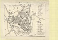
Plan de la ville d'Ypres
-
Date
-
1914
-
Subject
-
World War, 1914-1918, World War, 1914-1918--Belgium
-
Identifier
-
macrepo:71270, local: PC0562
-
![[Plan of Ypres]](/islandora/object/macrepo%3A71699/datastream/TN/view)
-
Title
-
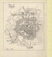
[Plan of Ypres]
-
Subject
-
World War, 1914-1918, World War, 1914-1918--Belgium
-
Identifier
-
macrepo:71699, local: PC0645ww1map
-
-
Title
-
Plan of Ypres
-
Subject
-
World War, 1914-1918, World War, 1914-1918--Belgium
-
Identifier
-
macrepo:71700, local: PC0646ww1map
-
-
Title
-
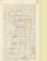
Index to Special Maps
-
Date
-
1918-03-02
-
Subject
-
World War, 1914-1918, World War, 1914-1918--Belgium--France
-
Identifier
-
macrepo:73992, local: PC0790
-

-
Title
-
Passchendaele Ridge
-
Date
-
1918-02-01
-
Subject
-
World War, 1914-1918, World War, 1914-1918--Belgium
-
Identifier
-
macrepo:73682, local: PC0730ww1map
-

-
Title
-
Passchendaele Ridge
-
Date
-
1918-03-07
-
Subject
-
World War, 1914-1918, World War, 1914-1918--Belgium
-
Identifier
-
macrepo:73687, local: PC0731ww1map
Pages