Skip to main content
Menu
Home
Digital Archive
McMaster
McMaster Library
Browse
By collection
By language
By location
By subject
About
About
Contact
Contact Us
Digital Preservation Policy
Strategic Framework
Implementation Plan
Copyright Approach for Library Digitization
Home
world
(x)
england
(x)
bath
(x)
Search Digital Archive
Search help
Search results
(81 - 100 of 480)
Pages
« first
‹ previous
…
3
4
5
6
7
…
next ›
last »
Title
A topographical map of Wiltshire, on a scale of 2 inches to a mile from an actual survey : [sheet 1]: by John Andrews & Andrew Dury. In the year 1773. To Noblemen, Gentlemen, Clergy, Freeholders of the County of Wilts....
Date
1773
Subject
Identifier
macrepo:80923, local: RMC_4334
Title
A map of the country sixty five miles, round London : [sheet 09]
Date
1791
Subject
Identifier
macrepo:79478, local: RMC_4291
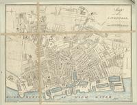
Title
Map of Liverpool
Date
1795
Subject
Identifier
macrepo:79564, local: RMC_4315
Title
An accurate map of the County of Lancaster divided into its hundreds, laid down from the best authorities: assisted by the most improved modern maps & charts with various extracts relative to its natural produce, trade, manufactures...
Date
1753
Subject
Identifier
macrepo:79563, local: RMC_4314
Title
A new and accurate map of the County of Cornwall, from an actual survey : [west sheet]
Date
1784
Subject
Identifier
macrepo:81094, local: RMC_4296_West
Title
A map of the County of Stafford: From an actual survey begun in the year 1769 and finished in 1775
Date
1775-11-07
Subject
Identifier
macrepo:81078, local: RMC_4327
Title
A map of Wiltshire: Taken from an actual survey being the index map to the large one
Date
1773
Subject
Identifier
macrepo:80894, local: RMC_4333
Title
A map of the County of Oxford, reduced from an actual survey in 16 sheets, made in the years 1793 and 1794
Date
1797
Subject
Identifier
macrepo:79571, local: RMC_4324
Title
A map of the County of Essex from an actual survey
Date
1777
Subject
Identifier
macrepo:79507, local: RMC_4305
Title
[Map of the County of Worcester...1772.]
Date
1772
Subject
Identifier
macrepo:80895, local: RMC_4335
Title
To the Right Honorable Thomas Orde Powlett, governor of the Isle of Wight
Date
1795-04-08
Subject
Identifier
macrepo:79508, local: RMC_4311
Title
The County Palantine of Lancaster : [north sheet]
Date
1786
Subject
Identifier
macrepo:81097, local: RMC_4316_1
Title
This new map of the County of Hereford: engrav'd from the original drawing made from an accurate survey proved by trigonometry
Date
1786-08-21
Subject
Identifier
macrepo:81082, local: RMC_4312
Title
The County of Westmoreland
Date
1770
Subject
Identifier
macrepo:80893, local: RMC_4332
Title
The County of Dorset
Date
1796-07-01
Subject
Identifier
macrepo:79504, local: RMC_4303
Title
Johnston's chart of the Baltic Sea, German Ocean & English Channel: with the adjoining countries showing the principal lines of railway communication to the coasts of Northern Europe
Date
1854
Subject
Identifier
macrepo:76359, local: RMC_5452
Title
A plan of Manchester and Salford
Date
1808
Subject
Identifier
macrepo:79566, local: RMC_4317
Title
Cruchley's improved geographical companion throughout England & Wales including part of Scotland
Date
1822-09-09
Subject
Identifier
macrepo:78032, local: RMC_4290
Title
Northvmbria, Cvmberlandia, et Dvnelmensis episcopatus
Date
1628
Subject
Identifier
macrepo:79542, local: RMC_107222r
Title
Nottingham Shire, Survey'd in 1774
Date
1776
Subject
Identifier
macrepo:79567, local: RMC_4323
Pages
« first
‹ previous
…
3
4
5
6
7
…
next ›
last »