Skip to main content
Menu
Home
Digital Archive
McMaster
McMaster Library
Browse
By collection
By language
By location
By subject
About
About
Contact
Contact Us
Digital Preservation Policy
Strategic Framework
Implementation Plan
Copyright Approach for Library Digitization
Home
*
(x)
war
(x)
mississauga
(x)
europe
(x)
Search Digital Archive
Search help
Search results
(21 - 40 of 3,851)
Pages
« first
‹ previous
1
2
3
4
5
…
next ›
last »
Title
Plan de Luxembourg et ses environs Dedié au Roy
Date
1741
Subject
Identifier
macrepo:78172, local: RMC_9434
Title
A map of the County of Essex from an actual survey taken in MDCCLXXII: LXXIII & MDCCLXXIV : [sheet 2]
Date
1777
Subject
Identifier
macrepo:79532, local: RMC_4306
Title
Carte chorographique des Pays-Bas Autrichiens [Sheet 03]: Sheets I, II, VI, VII
Date
1777
Subject
Identifier
macrepo:78192, local: RMC_9169
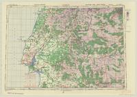
Title
Lisboa: 1:500,000 Europe (Air)
Date
1943
Subject
Aeronautical charts, Aeronautical charts--Europe
Identifier
macrepo:75457, local: WW2_Europe_500k_Air_NW_38_10
Title
Peloponnesus Peninsula, Greece: AAF aeronautical chart
Date
1945-01
Subject
Aeronautical charts, Aeronautical charts
Identifier
macrepo:76668, local: WW2_AirChart_World_1mil_0343
Title
Notes on Logic typescript of Bertrand Russell's translation
Date
1913-09
Subject
Logic., Logic.
Identifier
macrepo:76302, localcollection: RC0096, Box 5.56, 710.057824
Modat DT date
1913-09-01T00:00:00Z
Title
[Carte de France] : [Sheet 005, 006, 021 & 022]
Date
1750
Subject
Identifier
macrepo:78180, local: RMC_4399
Title
[Carte de France] : [Sheet 103, 104, 135 & 136]
Date
1750
Subject
Identifier
macrepo:78187, local: RMC_4399
Title
A map of the country sixty five miles, round London : [sheet 04]
Date
1791
Subject
Identifier
macrepo:79326, local: RMC_4291
Title
Pyrenees Mts., France-Spain: AAF aeronautical chart
Date
1945-06
Subject
Aeronautical charts, Aeronautical charts
Identifier
macrepo:76655, local: WW2_AirChart_World_1mil_0319
Title
[Carte de France] : [Sheet 047 & 048]
Date
1750
Subject
Identifier
macrepo:78744, local: RMC_4399
Title
Le Havre, Reims Chain: Lattice Topographical Map
Date
1944-11
Subject
Identifier
macrepo:82171, local: WW2_Lattice_500k_LeHavre_ReimsChain
Title
A map of the County of Northumberland : [sheet 1]: with that part of the County of Durham that is north of the river tyne also the Town of Berwick and its bounds
Date
1769
Subject
Identifier
macrepo:79584, local: RMC_4322
Title
London - Berlin: Radar plotting chart
Date
1944-08
Subject
Identifier
macrepo:82168, local: WW2_Radar_1mil_London-Berlin
Title
Lake of Geneva, Switzerland: AAF aeronautical chart
Date
1945-02
Subject
Aeronautical charts, Aeronautical charts
Identifier
macrepo:76629, local: WW2_AirChart_World_1mil_0253
Title
[Carte de France] : [Sheet 097 & 098]
Date
1750
Subject
Identifier
macrepo:78885, local: RMC_4399
Title
[Carte de France] : [Sheet 129 & 130]
Date
1750
Subject
Identifier
macrepo:78952, local: RMC_4399
Title
Carte des environs de Luxembourg: avec les nouveaux Ouvrages et ses projets commences en 1741
Date
1741
Subject
Identifier
macrepo:78196, local: RMC_9435
Title
[Carte de France] : [Sheet 127 & 128]
Date
1750
Subject
Identifier
macrepo:78951, local: RMC_4399
Title
Scotland drawn and engrav'd from a series of angles and astronomical observations : [south sheet]
Date
01-01-1789
Subject
Identifier
macrepo:81080, local: RMC_4368_2
Pages
« first
‹ previous
1
2
3
4
5
…
next ›
last »