Search results
Pages
-
-
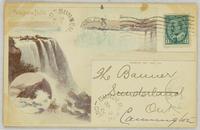
Title
-
Niagara Falls:
-
Date
-
1904-09-08
-
Subject
-
, --
-
Identifier
-
macrepo:102779, local: CPC-01468,
-
-
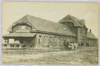
Title
-
G. T. R. Depot:
-
Date
-
-
Subject
-
, --
-
Identifier
-
macrepo:103125, local: CPC-01591,
-
-
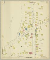
Title
-
Fonthill, Ont.
-
Date
-
1925-06
-
Subject
-
-
Identifier
-
macrepo:75729, local: Fonthill_FIP_1925_2
Pages