Search results
Pages
-
-
Title
-
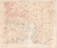
Map of the Somme Area:
-
Date
-
1916-12
-
Subject
-
World War, 1914-1918, World War, 1914-1918--Somme
-
Identifier
-
macrepo:93965, local: 473WW1MAP
-

-
Title
-
Index Diagram of Third Army Maps, Cambrai 1:100,000: Parts of Lens, Valenciennes, Amiens, St. Quentin
-
Date
-
1918-03
-
Subject
-
Maps, World War, 1914-1918, Maps, World War, 1914-1918
-
Identifier
-
macrepo:4154, local: 450WW1MAP
-
![[La Motte 36a.NE.]](/islandora/object/macrepo%3A4143/datastream/TN/view)
-
Title
-
[La Motte 36a.NE.]
-
Subject
-
Maps, World War, 1914-1918--Trench warfare--Maps, Maps, World War, 1914-1918--Trench warfare--Maps
-
Identifier
-
macrepo:4143, local: 228WW1MAP
-
![Maroeuil, [Plan of] Camp](/islandora/object/macrepo%3A4139/datastream/TN/view)
-
Title
-
Maroeuil, [Plan of] Camp
-
Subject
-
Maps, World War, 1914-1918, Maps, World War, 1914-1918
-
Identifier
-
macrepo:4139, local: 202WW1MAP
-
![[Bertincourt] 57c.SE](/islandora/object/macrepo%3A4077/datastream/TN/view)
-
Title
-
[Bertincourt] 57c.SE: France
-
Date
-
1917-06
-
Subject
-
Maps, World War, 1914-1918, Maps, World War, 1914-1918--f
-
Identifier
-
macrepo:4077, local: 004WW1MAP
-
-
Title
-
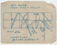
First Army Front, Ref Map E
-
Date
-
-
Subject
-
World War, 1914-1918, World War, 1914-1918--Vimy Ridge
-
Identifier
-
macrepo:93942, local: 470WW1MAP
-
![[Vimy Ridge]](/islandora/object/macrepo%3A93941/datastream/TN/view)
-
Title
-
[Vimy Ridge]:
-
Date
-
1916-09-16
-
Subject
-
World War, 1914-1918, World War, 1914-1918--Vimy Ridge
-
Identifier
-
macrepo:93941, local: 469WW1MAP
-

-
Title
-
Bois Rase
-
Date
-
1917-08-16
-
Subject
-
World War, 1914-1918, World War, 1914-1918--Hill 70
-
Identifier
-
macrepo:93944, local: 472WW1MAP
Pages