Skip to main content
Menu
Home
Digital Archive
McMaster
McMaster Library
Browse
By collection
By language
By location
By subject
About
About
Contact
Contact Us
Digital Preservation Policy
Strategic Framework
Implementation Plan
Copyright Approach for Library Digitization
Home
*
(x)
war
(x)
mississauga
(x)
ontario
(x)
wales
(x)
Search Digital Archive
Search help
Search results
(1 - 20 of 253)
Pages
1
2
3
4
5
…
next ›
last »
Title
Part the first of the general survey of England and Wales containing the whole of Essex... : [sheet 3]
Date
1805
Subject
Identifier
macrepo:79547, local: RMC_4307
Title
Pennine Chain, England: AAF aeronautical chart
Date
1943-09
Subject
Aeronautical charts, Aeronautical charts
Identifier
macrepo:76598, local: WW2_AirChart_World_1mil_0171
Title
The Border: Ordnance Survey of Great Britain (Aeronautical map) 1:500,000 R.A.F. (War)
Date
1945
Subject
Identifier
macrepo:82184, local: WW2_GreatBritain_500k_4_2ndEd
Title
Part the first of the general survey of England and Wales containing the whole of Essex... : [sheet 1]
Date
1805
Subject
Identifier
macrepo:79543, local: RMC_4307
Title
Part the first of the general survey of England and Wales containing the whole of Essex... : [sheet 4]
Date
1805
Subject
Identifier
macrepo:79548, local: RMC_4307
Title
Part the first of the general survey of England and Wales containing the whole of Essex... : [sheet 2]
Date
1805
Subject
Identifier
macrepo:79546, local: RMC_4307
Title
Prince of Wales MTS, Greenland: AAF aeronautical chart
Date
1944-09
Subject
Aeronautical charts, Aeronautical charts
Identifier
macrepo:76573
Title
Cruchley's improved geographical companion throughout England & Wales including part of Scotland
Date
1822-09-09
Subject
Identifier
macrepo:78032, local: RMC_4290
Title
[Map of the Six Counties of North-Wales] : [sheet 3]
Date
1795
Subject
Identifier
macrepo:80996, local: RMC_4364
Title
[Map of the Six Counties of North-Wales] : [sheet 2]
Date
1795
Subject
Identifier
macrepo:80995, local: RMC_4364
Title
[Map of the Six Counties of North-Wales] : [sheet 1]
Date
1795
Subject
Identifier
macrepo:80994, local: RMC_4364
Title
A new map of England & Wales. Drawn from several surveys &c on the new projection : [sheet 1]
Date
1792
Subject
Identifier
macrepo:80992, local: RMC_4363
Title
A new map of England & Wales. Drawn from several surveys &c on the new projection : [sheet 2]
Date
1792
Subject
Identifier
macrepo:80993, local: RMC_4363
Title
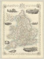
England and Wales
Date
1850
Subject
Identifier
macrepo:81377, local: RMC_107788
Title
North Midlands and Lincolnshire: Ordnance Survey of Great Britain : 1/4-inch to one mile, England & Wales
Date
1943
Subject
Identifier
macrepo:61976, local: WW2_England_Wales_253K_06
Title
The Highlands: Ordnance Survey of Great Britain (Aeronautical map) 1:500,000 R.A.F. (War)
Date
1944
Subject
Aeronautical charts, Aeronautical charts--Great Britain
Identifier
macrepo:70058, local: WW2_GreatBritain_500k_3
Title
The Border: Ordnance Survey of Great Britain (Aeronautical map) 1:500,000 R.A.F. (War)
Date
1945
Subject
Aeronautical charts, Aeronautical charts--Great Britain
Identifier
macrepo:70059, local: WW2_GreatBritain_500k_4
Title
Midlands and Wales: Ordnance Survey of Great Britain (Aeronautical map) 1:500,000 R.A.F. (War)
Date
1944
Subject
Aeronautical charts, Aeronautical charts--Great Britain
Identifier
macrepo:70060, local: WW2_GreatBritain_500k_5
Title
Strait of Dover: Ordnance Survey of Great Britain (Aeronautical map) 1:500,000 R.A.F. (War)
Date
1945
Subject
Aeronautical charts, Aeronautical charts--Great Britain
Identifier
macrepo:70065, local: WW2_GreatBritain_500k_8
Title
North Sea: Ordnance Survey of Great Britain (Aeronautical map) 1:500,000 R.A.F. (War)
Date
1945
Subject
Aeronautical charts, Aeronautical charts--Great Britain
Identifier
macrepo:70063, local: WW2_GreatBritain_500k_6
Pages
1
2
3
4
5
…
next ›
last »