Skip to main content
Menu
Home
Digital Archive
McMaster
McMaster Library
Browse
By collection
By language
By location
By subject
About
About
Contact
Contact Us
Digital Preservation Policy
Strategic Framework
Implementation Plan
Copyright Approach for Library Digitization
Home
*
(x)
ontario
(x)
belgium
(x)
region
(x)
Search Digital Archive
Search help
Search results
(1 - 20 of 483)
Pages
1
2
3
4
5
…
next ›
last »
Title
Carte des environs de la Mer-Noire: où se trouvent l'Ukrayne, la Petite Tartarie, la Circassie, la Georgie, et les confins de la Russie Europeenne, et de la Turquie
Date
1783
Subject
Identifier
macrepo:81404, local: RMC_9487
Title
A map of North America from the latest surveys and maps
Date
1768
Subject
Identifier
macrepo:76554, local: RMC_106457
Title
Carte de la partie méridionale du comté de Nice, relative aux mouvemens faits par l'Armée Combinée de France et d'Espagne: depuis le 1er. Octobre 1746 jusqu'au 6 Novembre de la même année
Date
1775
Subject
Austrian Succession, War of, 1740-1748, Austrian Succession, War of, 1740-1748--Nice Region (France)
Identifier
macrepo:81359, local: RMC_F57_Comte_de_Nice
Title
Prospect, Grundris und Gegent der Königl. Schwed. Vestung Stralsund: wie solche den 15 Julÿ Ao. 1715 von den Nordischen Hohen Allÿrten ist belagert worden
Date
1715
Subject
Identifier
macrepo:82213, local: RMC_4219
Title
Carte de la partie septentrionale de l'Empire Otoman dédiée a Monseigneur le Comte de Vergennes
Date
1774
Subject
Identifier
macrepo:81936, local: RMC_9489
Title
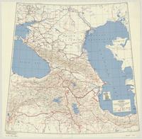
Caucasus : special strategic map
Date
1943
Subject
Transportation, Transportation--Caucasus Region--Soviet Union
Identifier
macrepo:70124, local: ww2_strategic_map_Caucasus_2mil
Title
[Greater Hamilton Area, from Caledonia to Vineland, 1934-07-09] : [Flightline A4809-Photo 19]:
Date
Subject
Identifier
macrepo:72314, local: AirPhotos_Hamilton_1934_A4809-19
Title
[Greater Hamilton Area, from Caledonia to Vineland, 1934-07-01] : [Flightline A4701-Photo 24]:
Date
Subject
Identifier
macrepo:72308, local: AirPhotos_Hamilton_1934_A4701-24
Title
[Greater Hamilton Area, from Caledonia to Vineland, 1934-07-09] : [Flightline A4753-Photo 76]:
Date
Subject
Identifier
macrepo:71881, local: AirPhotos_Hamilton_1934_A4753-76
Title
[Greater Hamilton Area, from Caledonia to Vineland, 1934-07-01] : [Flightline A4702-Photo 20]:
Date
Subject
Identifier
macrepo:71874, local: AirPhotos_Hamilton_1934_A4702-20
Title
[Regional Municipality of Hamilton-Wentworth and surrounding area, 1954] : [Flightline 4309-Photo 8]:
Date
1954
Subject
Identifier
macrepo:73050, local: AirPhotos_Hamilton_1954-1955_4309-8
Title
[Regional Municipality of Hamilton-Wentworth and surrounding area, 1954] : [Flightline 4313-Photo 121]:
Date
1954
Subject
Identifier
macrepo:73052, local: AirPhotos_Hamilton_1954-1955_4313-121
Title
[Regional Municipality of Hamilton-Wentworth and surrounding area, 1954] : [Flightline 4323-Photo 177]:
Date
1954
Subject
Identifier
macrepo:73045, local: AirPhotos_Hamilton_1954-1955_4323-177
Title
La Pensilvania, la Nuova York, il Jersey Settentriole.: con la parte occidentale del Connecticut, Massachusset-s-Bay e l'Irochesia
Date
1779
Subject
Identifier
macrepo:76560, local: RMC_107021
Title
Carte qui représente les différentes connoissances que l'on a eues des terres Arctiques depuis 1650 jusqu'en 1747: ausquelles il faut comparer la carte suivante ce. 10
Date
1773
Subject
Identifier
macrepo:76556, local: RMC_107008
Title
The discoveries of the expedition under the command of Captain Franklin R.N. near the mouth of the Mackenzie River: and on the sea coast east & west, A.D. 1825-26
Date
1828-04
Subject
Identifier
macrepo:21587, local: RMC_2583
Title
A particular map of the American lakes, rivers &c.
Date
1790-06-25
Subject
Identifier
macrepo:22624, local: RMC_6258
Title
Partie de l'Amerique septentrionale qui comprend le Canada, la Louisiane le Labrador, le Groenland, les Etats-Unis et la Floride
Date
1783
Subject
Identifier
macrepo:21608, local: RMC_3840
Title
A chart of the south-east coast of Newfoundland
Date
1780
Subject
Coasts, Coasts--Newfoundland and Labrador--Placentia Bay Region (N.L.)
Identifier
macrepo:21590, local: RMC_3823
Title
A new map of Canada, also the north parts of New England and New York; with Nova Scotia and Newfound Land
Date
1760
Subject
Identifier
macrepo:26874, local: RMC_107315
Pages
1
2
3
4
5
…
next ›
last »