Search results
Pages
-
-
Title
-
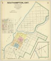
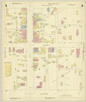
Southampton, Ont.
-
Date
-
1928-05
-
Subject
-
-
Identifier
-
macrepo:88113, local: Southampton_FIP_1928_01
-
-
Title
-
Southampton, Ont.
-
Date
-
1928-05
-
Subject
-
-
Identifier
-
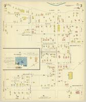
macrepo:88130, local: Southampton_FIP_1928_03
-
-
Title
-
Southampton, Ont.
-
Date
-
1928-05
-
Subject
-
-
Identifier
-
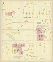
macrepo:88126, local: Southampton_FIP_1928_02
-
-
Title
-
Southampton, Ont.
-
Date
-
1928-05
-
Subject
-
-
Identifier
-
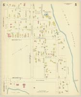
macrepo:88140, local: Southampton_FIP_1928_05
-
-
Title
-
Southampton, Ont.
-
Date
-
1928-05
-
Subject
-
-
Identifier
-
macrepo:88137, local: Southampton_FIP_1928_04
-

-
Title
-
Brighton, Ont.
-
Date
-
1926-07
-
Subject
-
-
Identifier
-
macrepo:81270, local: Brighton_FIP_1926_01
-
-
Title
-
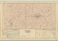
W. Zorra Township
-
Date
-
1876
-
Subject
-
-
Identifier
-
macrepo:81290, local: RMC_107785
Pages