Skip to main content
Menu
Home
Digital Archive
McMaster
McMaster Library
Browse
By collection
By language
By location
By subject
About
About
Contact
Contact Us
Digital Preservation Policy
Strategic Framework
Implementation Plan
Copyright Approach for Library Digitization
Home
*
(x)
ont
(x)
asia
(x)
canada
(x)
waterloo
(x)
ontario
(x)
bay
(x)
Search Digital Archive
Search help
Search results
(1 - 20 of 57)
Pages
1
2
3
next ›
last »
Title
Cape Henrietta Maria, Ontario, Canada: AAF aeronautical chart
Date
1944-07
Subject
Aeronautical charts, Aeronautical charts
Identifier
macrepo:76601, local: WW2_AirChart_World_1mil_0181
Title
Carte qui représente les différentes connoissances que l'on a eues des Terres Arctiques depuis 1650 jusqu'en 1747: ausquelles il faut comparer la Carte suivante Ce. 10
Date
1773
Subject
Identifier
macrepo:78177, local: RMC_107008
Title
Map of Nova Scotia, or Acadia; with the islands of Cape Breton and St. John's, from actual surveys
Date
1768
Subject
Identifier
macrepo:81601, local: RMC_102941s
Title
A plan of the city, and fortifications, of Louisburg; from a survey made by Richard Gridley, Lieut. Coll. ... in 1745: [and] A plan of the city and harbour of Louisburg, with the French batteries that defended it and those of the English...in 1758
Date
1758-10-09
Subject
Identifier
macrepo:81558, local: RMC_106454
Title
North Bay, ON. 1:63,360. Map sheet 031L06, [ed. 1], 1943:
Date
1943
Subject
, --
Identifier
macrepo:88123, local: HTDP63360K031L06_1943_MB
Title
Barry's Bay, ON. 1:63,360. Map sheet 031F05, [ed. 1], 1948:
Date
1948
Subject
, --
Identifier
macrepo:88018, local: HTDP63360K031F05_1948_UTM
Title
Leigh Bay, ON. 1:25,000. Map sheet 041K09D, [ed. 1], 1965:
Date
1965
Subject
, --
Identifier
macrepo:88980, local: HTDP25K041K09d_1965
Title
Leigh Bay, ON. 1:25,000. Map sheet 041K09D, [ed. 2], 1976:
Date
1976
Subject
, --
Identifier
macrepo:88981, local: HTDP25K041K09d_1976
Title
Thunder Bay East, ON. 1:25,000. Map sheet 052A06G, [ed. 1], 1970:
Date
1970
Subject
, --
Identifier
macrepo:88985, local: HTDP25K052A06g_1970
Title
Yukon map : sheet no. 01
Date
1898-06
Subject
Identifier
macrepo:81238, local: Yukon_Goldrush_Sheet01
Title
Gravelly Bay, ON. 1:25,000. Map sheet 040I09A, [ed. 1], 1969:
Date
1969
Subject
, --
Identifier
macrepo:88710, local: HTDP25K040I09a_1969
Title
Big Rice Bay, ON. 1:25,000. Map sheet 040I09C, [ed. 1], 1970:
Date
1970
Subject
, --
Identifier
macrepo:88712, local: HTDP25K040I09c_1970
Title
Mallorytown Landing (Chippewa Bay), ON. 1:25,000. Map sheet 031B05F, [ed. 1], 1968:
Date
1968
Subject
, --
Identifier
macrepo:88538, local: HTDP25K031B05f_1968
Title
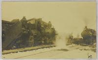
Train crash outside of station:
Date
Subject
, --
Identifier
macrepo:104591, local: CPC-01943,
Title
Trainwrech beside station:
Date
Subject
, --
Identifier
macrepo:104624, local: CPC-01965,
Title
Trains passing:
Date
1919-xx-xx
Subject
, --
Identifier
macrepo:104654, local: CPC-01944,
Title
Chart showing the track of the 'D.S.S. Alert' Hudson's Bay Expedition 1885:
Date
1886
Subject
D.S.S. Alert (ship), D.S.S. Alert (ship)--Hudson Bay
Identifier
macrepo:93960, local: RMC_107811
Title
Partie de l'Amerique septentrionale qui comprend le Canada, la Louisiane le Labrador, le Groenland, les Etats-Unis et la Floride
Date
1783
Subject
Identifier
macrepo:21608, local: RMC_3840
Title
Carte des isles de Miquelon et de St. Pierre et la coste de Terre-neuve voisine
Date
1764
Subject
Identifier
macrepo:21593, local: RMC_3828
Title
A chart of the south-east coast of Newfoundland
Date
1780
Subject
Coasts, Coasts--Newfoundland and Labrador--Placentia Bay Region (N.L.)
Identifier
macrepo:21590, local: RMC_3823
Pages
1
2
3
next ›
last »