Skip to main content
Menu
Home
Digital Archive
McMaster
McMaster Library
Browse
By collection
By language
By location
By subject
About
About
Contact
Contact Us
Digital Preservation Policy
Strategic Framework
Implementation Plan
Copyright Approach for Library Digitization
Home
*
(x)
ont
(x)
asia
(x)
canada
(x)
fire
(x)
bay
(x)
Search Digital Archive
Search help
Search results
(1 - 20 of 85)
Pages
1
2
3
4
5
next ›
last »
Title
Cape Henrietta Maria, Ontario, Canada: AAF aeronautical chart
Date
1944-07
Subject
Aeronautical charts, Aeronautical charts
Identifier
macrepo:76601, local: WW2_AirChart_World_1mil_0181
Title
Carte qui représente les différentes connoissances que l'on a eues des Terres Arctiques depuis 1650 jusqu'en 1747: ausquelles il faut comparer la Carte suivante Ce. 10
Date
1773
Subject
Identifier
macrepo:78177, local: RMC_107008
Title
Map of Nova Scotia, or Acadia; with the islands of Cape Breton and St. John's, from actual surveys
Date
1768
Subject
Identifier
macrepo:81601, local: RMC_102941s
Title
A plan of the city, and fortifications, of Louisburg; from a survey made by Richard Gridley, Lieut. Coll. ... in 1745: [and] A plan of the city and harbour of Louisburg, with the French batteries that defended it and those of the English...in 1758
Date
1758-10-09
Subject
Identifier
macrepo:81558, local: RMC_106454
Title
North Bay, ON. 1:63,360. Map sheet 031L06, [ed. 1], 1943:
Date
1943
Subject
, --
Identifier
macrepo:88123, local: HTDP63360K031L06_1943_MB
Title
Barry's Bay, ON. 1:63,360. Map sheet 031F05, [ed. 1], 1948:
Date
1948
Subject
, --
Identifier
macrepo:88018, local: HTDP63360K031F05_1948_UTM
Title
Leigh Bay, ON. 1:25,000. Map sheet 041K09D, [ed. 1], 1965:
Date
1965
Subject
, --
Identifier
macrepo:88980, local: HTDP25K041K09d_1965
Title
Leigh Bay, ON. 1:25,000. Map sheet 041K09D, [ed. 2], 1976:
Date
1976
Subject
, --
Identifier
macrepo:88981, local: HTDP25K041K09d_1976
Title
Thunder Bay East, ON. 1:25,000. Map sheet 052A06G, [ed. 1], 1970:
Date
1970
Subject
, --
Identifier
macrepo:88985, local: HTDP25K052A06g_1970
Title
Conibas regio cvm vicinis gentibvs
Date
1597
Identifier
macrepo:81289, local: RMC_107754
Title
Yukon map : sheet no. 01
Date
1898-06
Subject
Identifier
macrepo:81238, local: Yukon_Goldrush_Sheet01
Title
Iceboating:
Date
1903-09
Subject
, --
Identifier
macrepo:99563, local: CPC-00108,
Title
Freight Handler's Strike:
Date
1909-08-13
Subject
, --
Identifier
macrepo:101255, local: CPC-00656,
Title
T. Eaton Co. store and Arthur St. looking West:
Date
Subject
, --
Identifier
macrepo:102120, local: CPC-01180,
Title
Turning of First Sod of G. T. P.:
Date
1905-09-xx
Subject
, --
Identifier
macrepo:102812, local: CPC-01447,
Title
Signing the visitor's book at the boundary of Port Arthur and Fort William, Ont.:
Date
1939-05-23
Subject
, --
Identifier
macrepo:102917, local: CPC-01456,
Title
Thunder Bay Beach:
Date
Subject
, --
Identifier
macrepo:103947, local: CPC-01789,
Title
Laying Corner Stone St. Mary's Church:
Date
1907-01-08
Subject
, --
Identifier
macrepo:103935, local: CPC-01774,
Title
T. Eaton Co. Ltd., Branch Store:
Date
Subject
, --
Identifier
macrepo:104137, local: CPC-01852,
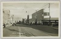
Title
Arthur St.:
Date
Subject
, --
Identifier
macrepo:104296, local: CPC-01853,
Pages
1
2
3
4
5
next ›
last »