Search results
Pages
-
-
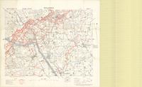
Title
-
Hollebeke
-
Date
-
1915-12-01
-
Subject
-
World War, 1914-1918, World War, 1914-1918--Belgium
-
Identifier
-
macrepo:71274, local: PC0567
-
-
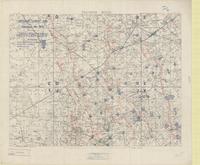
Title
-
Polygon Wood
-
Date
-
1917-08-27
-
Subject
-
World War, 1914-1918, World War, 1914-1918--Belgium
-
Identifier
-
macrepo:71707, local: PC0653ww1map
Pages