Search results
Pages
-
-
Title
-
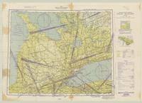
Camp Borden
-
Date
-
1943-04-28
-
Subject
-
-
Identifier
-
macrepo:81933, local: WW2_CanAero_500k_CampBorden
-
-
Title
-
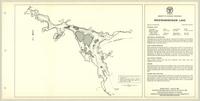
Weikwabinonaw Lake:
-
Date
-
1963
-
Subject
-
-
Identifier
-
macrepo:82041, local: ON_LakeMap_Weikwabinonaw_ThunderBay_1963
-
-
Title
-
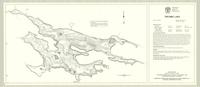
Ten Mile Lake:
-
Date
-
1967
-
Subject
-
-
Identifier
-
macrepo:82037, local: ON_LakeMap_TenMile_Algoma_1967
Pages