Skip to main content
Menu
Home
Digital Archive
McMaster
McMaster Library
Browse
By collection
By language
By location
By subject
About
About
Contact
Contact Us
Digital Preservation Policy
Strategic Framework
Implementation Plan
Copyright Approach for Library Digitization
Home
america
(x)
golden
(x)
1978
(x)
wentworth
(x)
Search Digital Archive
Search help
Search results
(4,501 - 4,520 of 4,577)
Pages
« first
‹ previous
…
224
225
226
227
228
next ›
last »
Title
A draught of the Gut of Canso, between Nova Scotia and Cape Breton Island, surveyed by the King's ships in 1761
Date
1775-03-25
Subject
Identifier
macrepo:21753, local: RMC_4151
Title
Carte réduite, des Costes de l'Acadie, de l'Isle Royale, et de la partie meridionale de l'Isle de Terre-Neuve
Date
1753
Subject
Identifier
macrepo:21757, local: RMC_4157
Title
King's Bay ; Lunenberg
Date
1776-03-11
Subject
Identifier
macrepo:21758, local: RMC_4158
Title
Port Shediack ; Cocagne
Date
1776-06-19
Subject
Identifier
macrepo:21759, local: RMC_4159
Title
Idee de la rade du Mingan suivant le journal de la fregate du roy La Diane en 1755
Date
1764
Subject
Identifier
macrepo:21708, local: RMC_4146
Title
Plan du Port Dauphin et de sa rade avec l'entrée de Labrador
Date
1744
Subject
Identifier
macrepo:21710, local: RMC_4148
Title
Baye Ste. Anne ou le Port Dauphin dans l'Isle Royale
Date
1764
Subject
Identifier
macrepo:21711, local: RMC_4149
Title
A new map of Nova Scotia, and Cape Breton Island with the adjacent parts of New England and Canada: composed from a great number of actual surveys; and other materials regulated by many new astronomical observations....
Date
1775-06-15
Subject
Identifier
macrepo:22625, local: RMC_6259
Title
Map of the seat of Riel's insurrection: showing the connection of Prince Albert with other points in the North West; trails, telegraph lines, &c., &c.
Date
1885-03-31
Subject
Riel Rebellion, 1885, Riel Rebellion, 1885--Prince Albert Region (Sask.)--Saskatchewan
Identifier
macrepo:22620, local: RMC_6187
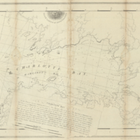
Title
Charlotte Bay
Date
1776-02-11
Subject
Identifier
macrepo:22609, local: RMC_4993
Title
A map of the British & French plantations in North America
Date
1755
Subject
Identifier
macrepo:31286, local: RMC_107662
Title
Sketch of Niagara River between Queenston & Chippewa
Date
1831
Subject
Identifier
macrepo:32234, local: RMC_107041
Title
Carte du cours du fleuve de St. Laurent depuis son embouchure jusqu'au dessus de Quebec: pour servir à l'Histoire générale des voyages
Date
1757
Subject
Identifier
macrepo:32237, local: RMC_107044
Title
Carte des parties du Nord-Ouest de l'Amerique suivant les voyages de Middleton et d'Ellis en 1742 et 1746: pour chercher un passage dans la Mer du Sud
Date
1753
Subject
Identifier
macrepo:32221, local: RMC_107032
Title
Map of Canada East or Lower Canada, compiled from government plans, original documents and observations
Date
1855
Subject
Identifier
macrepo:31261, local: RMC_107449
Title
A map of Canada and the north part of Louisiana with the adjacent countrys
Date
1760
Subject
Identifier
macrepo:31345, local: RMC_106455
Title
Sketch of Nootka Sound: A. ship cove {Lat. 49°.36'.N. Long. 233'.18.E. Var.17°.49'.E.
Date
1778
Subject
Identifier
macrepo:32259, local: RMC_107018
Title
Partie de l'Amérique Septentrionale: qui comprend le Canada, la Louisiane, le Labrador, le Groenland, les Etats-Unis et la Floride
Date
1783
Subject
Identifier
macrepo:32251, local: RMC_107009
Title
Sketch of Nootka Sound: A. ship cove {Lat. 49°.36'.N. Long. 233.18.E. Var.17°.49'.E.
Date
1778
Subject
Identifier
macrepo:32260, local: RMC_107019
Title
Some observations and sketches of the River St. Lawrence, made in the year 1765
Date
1765
Subject
Identifier
macrepo:31339, local: RMC_102973
Pages
« first
‹ previous
…
224
225
226
227
228
next ›
last »