Search results
Pages
-

-
Title
-
Niagara
-
Date
-
1937
-
Subject
-
-
Identifier
-
macrepo:77626, local: WWII_Canada_Niagara
-
-
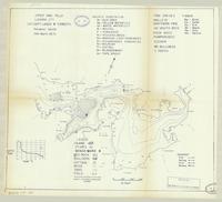
Title
-
Upper High Falls:
-
Date
-
1966
-
Subject
-
-
Identifier
-
macrepo:82039, local: ON_LakeMap_UpperHighFalls_Lanark_1966
-
-
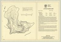
Title
-
Little Clear Lake:
-
Date
-
1967
-
Subject
-
-
Identifier
-
macrepo:81989, local: ON_LakeMap_LittleClear_Frontenac_1967
Pages