Skip to main content
Menu
Home
Digital Archive
McMaster
McMaster Library
Browse
By collection
By language
By location
By subject
About
About
Contact
Contact Us
Digital Preservation Policy
Strategic Framework
Implementation Plan
Copyright Approach for Library Digitization
Home
canada
(x)
wentworth
(x)
cambridg
(x)
bay
(x)
ontario
(x)
Search Digital Archive
Search help
Search results
(1 - 20 of 77)
Pages
1
2
3
4
next ›
last »
Title
Carte qui représente les différentes connoissances que l'on a eues des Terres Arctiques depuis 1650 jusqu'en 1747: ausquelles il faut comparer la Carte suivante Ce. 10
Date
1773
Subject
Identifier
macrepo:78177, local: RMC_107008
Title
The River, from Caledonia Dam:
Date
Subject
, --
Identifier
macrepo:149973, local: CPC-02348,
Title
Carte de la Baye de Hudson pour servir à l'Histoire generale des voyages
Date
1757
Subject
Identifier
macrepo:26879, local: RMC_107319
Title
Carte de la Baye de Hudson, pour servir à l'Histoire générale des voyages
Date
1757
Subject
Identifier
macrepo:32220, local: RMC_107031
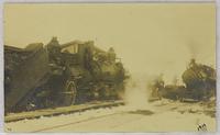
Title
Train crash outside of station:
Date
Subject
, --
Identifier
macrepo:104591, local: CPC-01943,
Title
Trainwrech beside station:
Date
Subject
, --
Identifier
macrepo:104624, local: CPC-01965,
Title
Trains passing:
Date
1919-xx-xx
Subject
, --
Identifier
macrepo:104654, local: CPC-01944,
Title
Chart showing the track of the 'D.S.S. Alert' Hudson's Bay Expedition 1885:
Date
1886
Subject
D.S.S. Alert (ship), D.S.S. Alert (ship)--Hudson Bay
Identifier
macrepo:93960, local: RMC_107811
Title
Partie de l'Amérique Septentrionale: qui comprend le Canada, la Louisiane, le Labrador, le Groenland, les Etats-Unis et la Floride
Date
1783
Subject
Identifier
macrepo:32251, local: RMC_107009
Title
Cape Henrietta Maria, Ontario, Canada: AAF aeronautical chart
Date
1944-07
Subject
Aeronautical charts, Aeronautical charts
Identifier
macrepo:76601, local: WW2_AirChart_World_1mil_0181
Title
North Bay, ON. 1:63,360. Map sheet 031L06, [ed. 1], 1943:
Date
1943
Subject
, --
Identifier
macrepo:88123, local: HTDP63360K031L06_1943_MB
Title
Barry's Bay, ON. 1:63,360. Map sheet 031F05, [ed. 1], 1948:
Date
1948
Subject
, --
Identifier
macrepo:88018, local: HTDP63360K031F05_1948_UTM
Title
Leigh Bay, ON. 1:25,000. Map sheet 041K09D, [ed. 1], 1965:
Date
1965
Subject
, --
Identifier
macrepo:88980, local: HTDP25K041K09d_1965
Title
Leigh Bay, ON. 1:25,000. Map sheet 041K09D, [ed. 2], 1976:
Date
1976
Subject
, --
Identifier
macrepo:88981, local: HTDP25K041K09d_1976
Title
Thunder Bay East, ON. 1:25,000. Map sheet 052A06G, [ed. 1], 1970:
Date
1970
Subject
, --
Identifier
macrepo:88985, local: HTDP25K052A06g_1970
Title
Gravelly Bay, ON. 1:25,000. Map sheet 040I09A, [ed. 1], 1969:
Date
1969
Subject
, --
Identifier
macrepo:88710, local: HTDP25K040I09a_1969
Title
Big Rice Bay, ON. 1:25,000. Map sheet 040I09C, [ed. 1], 1970:
Date
1970
Subject
, --
Identifier
macrepo:88712, local: HTDP25K040I09c_1970
Title
Allgemeine Uebersicht der von den Capitains Ross Parry und Francklin in den Fahren 1818. 19. 20. und 1821 Gemachten Entdeckungen
Date
1823
Subject
Identifier
macrepo:21568, local: RMC_2562
Title
An outline to shew the connected discoverie of Captains Ross, Parry & Franklin in the years 1818, 19, 20 and 21
Date
1823-03
Subject
Identifier
macrepo:21569, local: RMC_2569
Title
Meldrum Bay, ON. 1:63,360. Map sheet 041G14, [ed. 1], 1951:
Date
1951
Subject
, --
Identifier
macrepo:88267, local: HTDP63360K041G14_1951
Pages
1
2
3
4
next ›
last »