Skip to main content
Menu
Home
Digital Archive
McMaster
McMaster Library
Browse
By collection
By language
By location
By subject
About
About
Contact
Contact Us
Digital Preservation Policy
Strategic Framework
Implementation Plan
Copyright Approach for Library Digitization
Home
canada
(x)
latitud
(x)
québec
(x)
ontario
(x)
island
(x)
Search Digital Archive
Search help
Search results
(1 - 20 of 25)
Pages
1
2
next ›
last »
Title
La terra de Hochelaga nella Nova Francia
Date
1606
Identifier
macrepo:25553, local: RMC_107203
Title
Map of Quebec in counties
Date
1867
Subject
Identifier
macrepo:26968, local: RMC_107328
Title
Map of the eastern townships of Lower Canada
Date
1834
Subject
Identifier
macrepo:26970, local: RMC_107329
Title
Map of Canada East in counties
Date
1862
Subject
Identifier
macrepo:26960, local: RMC_107327
Title
This topographical map of the districts of Quebec, Three Rivers, St. Francis and Gaspé, Lower Canada: exhibiting the new civil division of the districts into counties pursuant to a recent act of the Provincial Legislature
Date
1831-05-02
Subject
Identifier
macrepo:81918, local: RMC_102982_sw
Title
Carte régionale de la province de Québec: comprenant les comtés de Temiscouata, Rimouski, Matane, Bonaventure et Gaspé
Date
1895-12
Subject
Identifier
macrepo:31135, local: RMC_107405
Title
Map of Canada East or Lower Canada, compiled from government plans, original documents and observations
Date
1855
Subject
Identifier
macrepo:31261, local: RMC_107449
Title
This topographical map of the districts of Quebec, Three Rivers, St. Francis and Gaspé, Lower Canada: exhibiting the new civil division of the districts into counties pursuant to a recent act of the Provincial Legislature
Date
1831-05-02
Subject
Identifier
macrepo:81919, local: RMC_102982_ne
Title
A plan of the city of Quebec the capital of Canada
Date
1760-01-15
Subject
Identifier
macrepo:31346, local: RMC_106456
Title
Profil de la ville de Quebec et de ses environs attaquée par les Anglois en l'année 1691
Date
1703
Subject
Identifier
macrepo:31341, local: RMC_106136
Title
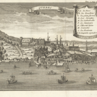
Quebec
Date
1722
Subject
Identifier
macrepo:31344, local: RMC_106139
Title
City of Quebec, 1830
Date
1830
Subject
Identifier
macrepo:31416, local: RMC_102780
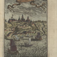
Title
Qvebec
Date
1683
Subject
Identifier
macrepo:31414, local: RMC_106133
Title
Lower Canada, New Brunswick, Nova Scotia, Prince Edwards Id. Newfoundland, and a large portion of the United States
Date
1846-02-15
Subject
Identifier
macrepo:31427, local: RMC_107680
Title
This topographical map of the districts of Quebec, Three Rivers, St. Francis and Gaspé, Lower Canada: exhibiting the new civil division of the districts into counties pursuant to a recent act of the Provincial Legislature
Date
1831-05-02
Subject
Identifier
macrepo:81914, local: RMC_102982_n
Title
This topographical map of the districts of Quebec, Three Rivers, St. Francis and Gaspé, Lower Canada: exhibiting the new civil division of the districts into counties pursuant to a recent act of the Provincial Legislature
Date
1831-05-02
Subject
Identifier
macrepo:81917, local: RMC_102982_nw
Title
This topographical map of the districts of Quebec, Three Rivers, St. Francis and Gaspé, Lower Canada: exhibiting the new civil division of the districts into counties pursuant to a recent act of the Provincial Legislature
Date
1831-05-02
Subject
Identifier
macrepo:81920, local: RMC_102982_se
Title
This topographical map of the districts of Quebec, Three Rivers, St. Francis and Gaspé, Lower Canada: exhibiting the new civil division of the districts into counties pursuant to a recent act of the Provincial Legislature
Date
1831-05-02
Subject
Identifier
macrepo:81913, local: RMC_102982_s
Title
Plan of the military & naval operations, under the command of the immortal Wolfe, & Vice Admiral Saunders, before Quebec
Date
1841-05-01
Subject
Identifier
macrepo:31112, local: RMC_107401
Title
Air raid precautions map, Federal District of Ottawa
Date
1942-04
Subject
World War, 1939-1945
Identifier
macrepo:71533, local: WWII_Canada_Air_Raid_Precautions_Map
Pages
1
2
next ›
last »