Skip to main content
Menu
Home
Digital Archive
McMaster
McMaster Library
Browse
By collection
By language
By location
By subject
About
About
Contact
Contact Us
Digital Preservation Policy
Strategic Framework
Implementation Plan
Copyright Approach for Library Digitization
Home
canada
(x)
ontario
(x)
ont
(x)
rockwood
(x)
longitude
(x)
barton
(x)
county
(x)
Search Digital Archive
Search help
Search results
(1 - 20 of 46)
Pages
1
2
3
next ›
last »
Title
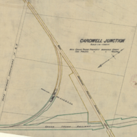
Cardwell Junction
Date
1903-08-07
Subject
Identifier
macrepo:26997, local: RMC_107343
Title
Map of the Saugeen Indian peninsula shewing the townships of Albemarle, Keppel, & Amabel: County of Bruce, Province of Canada
Date
1856
Subject
Identifier
macrepo:33181, local: RMC_107772
Title
Plan of the town of Goderich Upper Canada founded by the Canada Company 1829: Lat. 43°. 46m. N. Long. 81°. 53m. W.
Date
1831
Subject
Identifier
macrepo:31418, local: RMC_102781
Title
Counties of Hastings, Frontenac, Lennox and Addington
Date
1852
Subject
Identifier
macrepo:81565, local: RMC_6191e
Title
Counties of Essex, Kent, and Lambton
Date
1852
Subject
Identifier
macrepo:81571, local: RMC_6191k
Title
Counties of Middlesex, Oxford, and Norfolk
Date
1852
Subject
Identifier
macrepo:81567, local: RMC_6191g
Title
Counties of Peterborough, Durham, and Northumberland
Date
1852
Subject
Identifier
macrepo:81568, local: RMC_6191h
Title
Counties of York and Simcoe
Date
1852
Subject
Identifier
macrepo:81562, local: RMC_6191b
Title
Plan of Goodwin Park: being a subdivision of part of lot 34, concession IV, Township of Saltfleet
Date
1913-07-17
Subject
Identifier
macrepo:70518, local: RMC_7581
Title
Plan of Kenview Park: Being the subdivision of part of lots 56 & the Gore [lot 57] in Con. 2, Township of Ancaster
Date
1913
Subject
Identifier
macrepo:71311, local: RMC 7626
Title
Plan of Wilson Park: Being part of lot 33, Con 2 and part of parcel 'A' in Normanhurst, Township of Saltfleet
Date
1913-05-01
Subject
Identifier
macrepo:71172, local: RMC_7606/7
Title
Plan of the Village of Inverness, being the subdivision of lot no.1 first concession, Flamboro East [north sheet]
Date
1848
Subject
Identifier
macrepo:70078, local: RMC_7564B
Title
Plan of lots I to IX both inclusive in the Vth and VIth Concessions of Saltfleet: Surveyed under instructions from the Honble. the Commr. of Crown Lands
Date
1860-06-04
Subject
Identifier
macrepo:70742, local: RMC_7608
Title
Plan of Lawrence Park: being a subdivision of a part of lot 56, con. 1., Tp. of Ancaster
Date
1913-10-10
Subject
Identifier
macrepo:70140, local: RMC_7563
Title
Counties of Waterloo, Huron, Perth, and Bruce
Date
1852
Subject
Identifier
macrepo:81570, local: RMC_6191j
Title
Plan showing resubdivision of lots nos. 104 to 112 Allen & Matheson Survey
Date
1906-02-06
Subject
Identifier
macrepo:65228
Title
Plan of park-lots laid out in the north part of lot no.5 in the B.F. Con of the Township of Saltfleet
Date
1893-04
Subject
Identifier
macrepo:65257, local: RMC_7531
Title
Hatt's Survey Dundas
Date
1820
Subject
Identifier
macrepo:65229, local: RMC_7546/7
Title
Plan of survey of part of lot no 24 in the 2nd conn Flamboro' West containing 18 1/2 acres
Date
1853-11-18
Subject
Identifier
macrepo:63213, local: RMC_7494
Title
Plan of Enright's farm being composed of the rear part of lots 5&6 in the Second Concession of the Township of West Flamborough
Date
1871-08
Subject
Identifier
macrepo:65211
Pages
1
2
3
next ›
last »