Skip to main content
Menu
Home
Digital Archive
McMaster
McMaster Library
Browse
By collection
By language
By location
By subject
About
About
Contact
Contact Us
Digital Preservation Policy
Strategic Framework
Implementation Plan
Copyright Approach for Library Digitization
Home
canada
(x)
america
(x)
fire
(x)
chaplain
(x)
canada
(x)
cold
(x)
ont
(x)
bay
(x)
longitude
(x)
Search Digital Archive
Search help
Search results
(1 - 20 of 27)
Pages
1
2
next ›
last »
Title
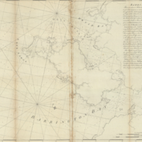
Carte qui représente les différentes connoissances que l'on a eues des Terres Arctiques depuis 1650 jusqu'en 1747: ausquelles il faut comparer la Carte suivante Ce. 10
Date
1773
Subject
Identifier
macrepo:78177, local: RMC_107008
Title
La parte occidentale della Nuova Francia o Canada
Date
1784
Subject
Identifier
macrepo:21585, local: RMC_2575
Title
Carte de la Baye de Hudson pour servir à l'Histoire generale des voyages
Date
1757
Subject
Identifier
macrepo:26879, local: RMC_107319
Title
Carte de la Baye de Hudson, pour servir à l'Histoire générale des voyages
Date
1757
Subject
Identifier
macrepo:32220, local: RMC_107031
Title
Chart showing the track of the 'D.S.S. Alert' Hudson's Bay Expedition 1885:
Date
1886
Subject
D.S.S. Alert (ship), D.S.S. Alert (ship)--Hudson Bay
Identifier
macrepo:93960, local: RMC_107811
Title
Partie de l'Amérique Septentrionale: qui comprend le Canada, la Louisiane, le Labrador, le Groenland, les Etats-Unis et la Floride
Date
1783
Subject
Identifier
macrepo:32251, local: RMC_107009
Title
Cape Henrietta Maria, Ontario, Canada: AAF aeronautical chart
Date
1944-07
Subject
Aeronautical charts, Aeronautical charts
Identifier
macrepo:76601, local: WW2_AirChart_World_1mil_0181
Title
Plan of the north shore of Lake Superior
Date
1863-01
Identifier
macrepo:91983, local: RMC_107794
Title
Bay Bulls, part of Newfoundland
Date
1755
Subject
Identifier
macrepo:23905, local: RMC_8952
Title
[Tor Bay, Nova Scotia]
Date
1775-12-08
Subject
Identifier
macrepo:22608, local: RMC_4990
Title
La Baja d'Hudson, terra di Labrador e Groenlandia con le isole adiacenti di nuova projezione
Date
1778
Subject
Identifier
macrepo:32215, local: RMC_107028
Title
Septemtrionaliora Americæ à Groenlandia, per Freta Davidis et Hudson, ad Terram Novam: De Noordelyckste zee kusten van America van Groenland door de Straet Davis ende Straet Hudson tot Terra Neuf
Date
1690
Subject
Identifier
macrepo:32258, local: RMC_107017
Title
Partie de la Nouvelle Bretagne
Date
1827
Subject
Identifier
macrepo:31423, local: RMC_102882
Title
Map of Nova Scotia, or Acadia; with the islands of Cape Breton and St. John's, from actual surveys
Date
1768
Subject
Identifier
macrepo:81601, local: RMC_102941s
Title
A plan of the city, and fortifications, of Louisburg; from a survey made by Richard Gridley, Lieut. Coll. ... in 1745: [and] A plan of the city and harbour of Louisburg, with the French batteries that defended it and those of the English...in 1758
Date
1758-10-09
Subject
Identifier
macrepo:81558, local: RMC_106454
Title
Conibas regio cvm vicinis gentibvs
Date
1597
Identifier
macrepo:81289, local: RMC_107754
Title
A chart of the south-east coast of Newfoundland
Date
1780
Subject
Coasts, Coasts--Newfoundland and Labrador--Placentia Bay Region (N.L.)
Identifier
macrepo:21590, local: RMC_3823
Title
Carte des bayes, rades, et port de Plaisance dans l'isle de Terre-Neuve
Date
1764
Subject
Identifier
macrepo:21588, local: RMC_3821
Title
A large and particular plan of Shegnekto Bay, and the circumjacent country: with the forts and settlements of the French 'till dispossess'd by the English in June 1755
Date
1755-08-16
Subject
Identifier
macrepo:21888, local: RMC_4247
Title
Barrington Bay
Date
1776-04-06
Subject
Identifier
macrepo:21763, local: RMC_4163
Pages
1
2
next ›
last »