Skip to main content
Menu
Home
Digital Archive
McMaster
McMaster Library
Browse
By collection
By language
By location
By subject
About
About
Contact
Contact Us
Digital Preservation Policy
Strategic Framework
Implementation Plan
Copyright Approach for Library Digitization
Home
canada
(x)
longitud
(x)
preston
(x)
counti
(x)
saint
(x)
Search Digital Archive
Search help
Search results
(21 - 40 of 42)
Pages
« first
‹ previous
1
2
3
next ›
last »
Title
A chart of the Magdalen Islands in the Gulf of St. Laurence surveyed in 1765
Date
1794
Subject
Identifier
macrepo:21756, local: RMC_4156
Title
Plan du Port Dauphin et de sa rade avec l'entrée de Labrador
Date
1744
Subject
Identifier
macrepo:21710, local: RMC_4148
Title
Baye Ste. Anne ou le Port Dauphin dans l'Isle Royale
Date
1764
Subject
Identifier
macrepo:21711, local: RMC_4149
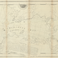
Title
Charlotte Bay
Date
1776-02-11
Subject
Identifier
macrepo:22609, local: RMC_4993
Title
Carte du cours du fleuve de St. Laurent depuis son embouchure jusqu'au dessus de Quebec: pour servir à l'Histoire générale des voyages
Date
1757
Subject
Identifier
macrepo:32237, local: RMC_107044
Title
Some observations and sketches of the River St. Lawrence, made in the year 1765
Date
1765
Subject
Identifier
macrepo:31339, local: RMC_102973
Title
An authentic plan of the River St. Laurence from Sillery, to the Fall of Montmorenci, with the operations of the Siege of Quebec: under the command of Vice-Adml. Saunders & Major Genl. Wolfe down to the 5, Sepr. 1759
Date
1759-09-05
Subject
Québec Campaign, Québec, 1759, Québec Campaign, Québec, 1759--Saint Lawrence River--Québec (Québec)
Identifier
macrepo:31413, local: RMC_106132
Title
St. Pierre les Becquets, Que.
Subject
Fire insurance, Fire insurance--Saint-Pierre-les-Besquets (Québec)--
Identifier
macrepo:48685
Title
An exact chart of the River St. Laurence, from Fort Frontenac to the Island of Anticosti shewing the soundings, rocks, shoals &c: with views of the lands and all necessary instructions for navigating that river to Quebec
Date
1775-05-25
Subject
Identifier
macrepo:76365, local: RMC_3844-w
Title
An exact chart of the River St. Laurence, from Fort Frontenac to the Island of Anticosti shewing the soundings, rocks, shoals &c: with views of the lands and all necessary instructions for navigating that river to Quebec
Date
1775-05-25
Subject
Identifier
macrepo:76367, local: RMC_3844-e
Title
Map of Nova Scotia, or Acadia; with the islands of Cape Breton and St. John's, from actual surveys
Date
1768
Subject
Identifier
macrepo:81600, local: RMC_102941n
Title
Suite du cours du fleuve de St. Laurent, depuis Quebec jusqu'au Lac Ontario: pour servir à l'Histoire générale des voyages
Date
1780
Subject
Identifier
macrepo:26944, local: RMC_107320
Title
A general chart of the Island of Newfoundland with the rocks & soundings
Date
1775-05-10
Subject
Identifier
macrepo:21591, local: RMC_3824
Title
Carte des isles de Miquelon et de St. Pierre et la coste de Terre-neuve voisine
Date
1764
Subject
Identifier
macrepo:21593, local: RMC_3828
Title
Map showing the different railways by which the eastern townships of Canada East may be reached
Date
1880
Subject
Railroads, Railroads--Ontario--Eastern Townships (Québec)--Northeastern States
Identifier
macrepo:26872, local: RMC_107314
Title
The River St. Lawrence, accurately drawn from d'Anville's map
Date
1791
Subject
Identifier
macrepo:21615, local: RMC_3843
Title
A new map of the Province of Quebec, according to the Royal Proclamation, of the 7th. of October 1763: from the French surveys connected with those made after the war
Date
1776-02-16
Subject
Identifier
macrepo:31842, local: RMC_107022
Title
A chart of the Banks of Newfoundland, drawn from a great number of hydrographical surveys: chiefly from those of Chabert, Cook and Fleurieu, connected and ascertained by astronomical observations
Date
1787-03-26
Subject
Identifier
macrepo:81603, local: RMC_8805
Title
Plan of the different channels, leading from Kingston to Lake Ontario
Date
1815-08-12
Subject
Identifier
macrepo:21584, local: RMC_2574
Title
Carte du cours du fleuve de Saint Laurent depuis Quebec jusqu'a la mer en deux feuilles....
Date
1761
Subject
Identifier
macrepo:21618, local: RMC_3845
Pages
« first
‹ previous
1
2
3
next ›
last »