Skip to main content
Menu
Home
Digital Archive
McMaster
McMaster Library
Browse
By collection
By language
By location
By subject
About
About
Contact
Contact Us
Digital Preservation Policy
Strategic Framework
Implementation Plan
Copyright Approach for Library Digitization
Home
europe
(x)
wale
(x)
belgium
(x)
cold
(x)
de
(x)
england
(x)
1939
(x)
sea
(x)
southend
(x)
Search Digital Archive
Search help
Search results
(1 - 7 of 7)
Title
North Sea: Ordnance Survey of Great Britain (Aeronautical map) 1:500,000 R.A.F. (War)
Date
1945
Subject
Aeronautical charts, Aeronautical charts--Great Britain
Identifier
macrepo:70063, local: WW2_GreatBritain_500k_6
Title
[Clacton on Sea & Harwich]
Date
1940
Subject
Topographic maps, Topographic maps--England--Wales
Identifier
macrepo:66505
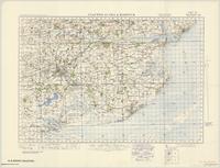
Title
Clacton on Sea & Harwich
Date
1940
Subject
Topographic maps, Topographic maps--England--Wales
Identifier
macrepo:66427
Title
Irish Sea: Ordnance Survey of Great Britain : 1/4-inch to one mile, England & Wales
Date
1944
Subject
Identifier
macrepo:61974, local: WW2_England_Wales_253K_02A
Title
Pennine Chain, England: AAF aeronautical chart
Date
1943-09
Subject
Aeronautical charts, Aeronautical charts
Identifier
macrepo:76598, local: WW2_AirChart_World_1mil_0171
Title
Great Britain: Europe, scale 1:1,000,000
Date
1942
Subject
Identifier
macrepo:70727, local: WW2_Europe_1mil_1
Title
Great Britain: Europe, scale 1:1,000,000
Date
1942
Subject
Identifier
macrepo:70728, local: WW2_Europe_1mil_2