Search results
Pages
-
-
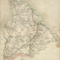
Title
-
Roads to Rochester, Canterbury, Margate, Ramsgate, Deal, Dover, Folkstone, Hythe, New Romney, Rye, Hastings & Eastbourne: (by Tonbridge)
-
Date
-
1815
-
Subject
-
-
Identifier
-
macrepo:31315, local: RMC_107669
-
![[Woldingham]](/islandora/object/macrepo%3A70052/datastream/TN/view)
-
Title
-
[Woldingham]
-
Date
-
1940
-
Subject
-
-
Identifier
-
macrepo:70052
-
![[Lingfield]](/islandora/object/macrepo%3A70054/datastream/TN/view)
-
Title
-
[Lingfield]
-
Date
-
1941
-
Subject
-
-
Identifier
-
macrepo:70054
-
![[Redhill]](/islandora/object/macrepo%3A70055/datastream/TN/view)
-
Title
-
[Redhill]
-
Date
-
1941
-
Subject
-
-
Identifier
-
macrepo:70055
-
![[Fleet]](/islandora/object/macrepo%3A70050/datastream/TN/view)
-
Title
-
[Fleet]
-
Date
-
1941
-
Subject
-
-
Identifier
-
macrepo:70050
Pages