Skip to main content
Menu
Home
Digital Archive
McMaster
McMaster Library
Browse
By collection
By language
By location
By subject
About
About
Contact
Contact Us
Digital Preservation Policy
Strategic Framework
Implementation Plan
Copyright Approach for Library Digitization
Home
europe
(x)
belgium
(x)
europ
(x)
england
(x)
devon
(x)
freeman
(x)
Search Digital Archive
Search help
Search results
(81 - 100 of 443)
Pages
« first
‹ previous
…
3
4
5
6
7
…
next ›
last »
Title
By permission, to His Royal Highness, George, Prince of Wales, Duke of Cornwall & Rothsay, and Earl of Chester : [sheet 2]: This survey of the County Palatine of Chester, is most humbly dedicated
Date
1794-06-01
Subject
Identifier
macrepo:79518, local: RMC_4295
Title
A map of Warwickshire: Drawn from an actual survey taken in the years 1787-1788-1789 by Willm. Yates & Sons for John Sharp.
Date
1793
Subject
Identifier
macrepo:81079, local: RMC_4331
Title
A map of the country sixty five miles, round London : [sheet 07]
Date
1791
Subject
Identifier
macrepo:79328, local: RMC_4291
Title
A map of the County of Essex from an actual survey taken in MDCCLXXII: LXXIII & MDCCLXXIV : [sheet 6]
Date
1777
Subject
Identifier
macrepo:79537, local: RMC_4306
Title
A map of the country sixty five miles, round London : [sheet 02]
Date
1791
Subject
Identifier
macrepo:79324, local: RMC_4291
Title
The County of Northampton : [sheet 2]
Date
1791
Subject
Identifier
macrepo:79480, local: RMC_4321
Title
To the Nobility Gentry Clergy and Freeholders of the County of Cumberland : [west sheet]
Date
1802
Subject
Identifier
macrepo:79502, local: RMC_4297
Title
The County of Northampton : [sheet 1]
Date
1791
Subject
Identifier
macrepo:79479, local: RMC_4321
Title
A map of the County of Essex from an actual survey taken in MDCCLXXII: LXXIII & MDCCLXXIV : [sheet 1]
Date
1777
Subject
Identifier
macrepo:79531, local: RMC_4306
Title
A map of the County of Essex from an actual survey taken in MDCCLXXII: LXXIII & MDCCLXXIV : [sheet 4]
Date
1777
Subject
Identifier
macrepo:79535, local: RMC_4306
Title
A map of the County of Essex from an actual survey taken in MDCCLXXII: LXXIII & MDCCLXXIV : [sheet 5]
Date
1777
Subject
Identifier
macrepo:79536, local: RMC_4306
Title
A map of the County of Essex from an actual survey taken in MDCCLXXII: LXXIII / & MDCCLXXIV : [sheet 9]
Date
1777
Subject
Identifier
macrepo:79541, local: RMC_4306
Title
A topographical map of the County of Sussex, divided into Rapes, Deanries and hundreds... : [east sheet]: planned from an actual survey by a scale of one inch to a statute mile; begun by W. Gardner and the late T. Yeakell....
Date
1795
Subject
Identifier
macrepo:80922, local: RMC_4329
Title
A map of the County of Essex from an actual survey taken in MDCCLXXII: LXXIII & MDCCLXXIV : [sheet 8]
Date
1777
Subject
Identifier
macrepo:79539, local: RMC_4306
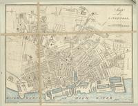
Title
Map of Liverpool
Date
1795
Subject
Identifier
macrepo:79564, local: RMC_4315
Title
An accurate map of the County of Lancaster divided into its hundreds, laid down from the best authorities: assisted by the most improved modern maps & charts with various extracts relative to its natural produce, trade, manufactures...
Date
1753
Subject
Identifier
macrepo:79563, local: RMC_4314
Title
A map of the County of Stafford: From an actual survey begun in the year 1769 and finished in 1775
Date
1775-11-07
Subject
Identifier
macrepo:81078, local: RMC_4327
Title
A map of Wiltshire: Taken from an actual survey being the index map to the large one
Date
1773
Subject
Identifier
macrepo:80894, local: RMC_4333
Title
A map of the County of Oxford, reduced from an actual survey in 16 sheets, made in the years 1793 and 1794
Date
1797
Subject
Identifier
macrepo:79571, local: RMC_4324
Title
A map of the County of Essex from an actual survey
Date
1777
Subject
Identifier
macrepo:79507, local: RMC_4305
Pages
« first
‹ previous
…
3
4
5
6
7
…
next ›
last »