Skip to main content
Menu
Home
Digital Archive
McMaster
McMaster Library
Browse
By collection
By language
By location
By subject
About
About
Contact
Contact Us
Digital Preservation Policy
Strategic Framework
Implementation Plan
Copyright Approach for Library Digitization
Home
europe
(x)
wale
(x)
itali
(x)
1989
(x)
france
(x)
Search Digital Archive
Search help
Search results
(1,501 - 1,520 of 1,582)
Pages
« first
‹ previous
…
74
75
76
77
78
…
next ›
last »
Title
Second Army area (east) : sketch map, showing supposed location of enemy's forces on 15th March, 1917
Date
1917-03-15
Subject
World War, 1914-1918, World War, 1914-1918--Belgium, France
Identifier
macrepo:73987, local: PC0785
Title
Second Army area (east) : sketch map, showing supposed location of enemy's forces on 15th February 1917
Date
1917-02-15
Subject
World War, 1914-1918, World War, 1914-1918--Belgium, France
Identifier
macrepo:73986, local: PC0784
Title
[Second] Army area no. 1 : Second Army lines of defence, 25th April 1918
Date
1918-04-25
Subject
World War, 1914-1918, World War, 1914-1918--Belgium--France
Identifier
macrepo:73995, local: PC0793
Title
[Second Army area before the Battle of Messines, 1917]
Date
1917-03-16
Subject
World War, 1914-1918, World War, 1914-1918--Belgium, France
Identifier
macrepo:73988, local: PC0786ww1map
Title
[Second Army area : Ypres, Lille Region, 1915]
Date
1915
Subject
World War, 1914-1918, World War, 1914-1918--Belgium--France
Identifier
macrepo:73985, local: PC0783ww1map
Title
Distribution of German Forces, 10-9-18
Date
1918-09-10
Subject
World War, 1914-1918, World War, 1914-1918--France
Identifier
macrepo:73983, local: PC0781
Title
Second Army M.T. circuits, eastern area, 15th May, 1918
Date
1918-05-14
Subject
World War, 1914-1918, World War, 1914-1918--Belgium--France
Identifier
macrepo:73993, local: PC0791
Title
[Second] Army area map, no. 6 : Second Army M.T. circuits
Date
1918-08
Subject
World War, 1914-1918, World War, 1914-1918--Belgium--France
Identifier
macrepo:73996, local: PC0794
Title
[Second] Army area map, no. 8 : hostile aerodromes and hospitals, from air photographs, April 1st - May 15th, 1918
Date
1918-06-06
Subject
World War, 1914-1918, World War, 1914-1918--Belgium--France
Identifier
macrepo:74003, local: PC0800ww1map
Title
[Second] Army area map, no. 9 : hostile aerodromes opposite Second Army front, June 6th 1918 (from air photographs)
Date
1918-06-06
Subject
World War, 1914-1918, World War, 1914-1918--Belgium--France
Identifier
macrepo:74060, local: PC0801ww1map
Title
[Second] Army area map, no. 9 : enemy hospital signs opposite Second Army front (from air photographs), June 6th, 1918
Date
1918-06-06
Subject
World War, 1914-1918, World War, 1914-1918--Belgium--France
Identifier
macrepo:74105, local: PC0802ww1map
Title
[Second] Army area map, no. 9 : hostile aerodromes opposite Second Army front, August 23rd, 1918 (from air photographs)
Date
1918-08-23
Subject
World War, 1914-1918, World War, 1914-1918--Belgium--France
Identifier
macrepo:74106, local: PC0803ww1map
Title
Army area map no. 10 : Watten Bridge Head - Merckeghem Switch - St. Omer - Sercus Line, signal communications
Date
1918-08-14
Subject
World War, 1914-1918, World War, 1914-1918--France
Identifier
macrepo:74107, local: PC0804
Title
Army area map no. 10 : Watten Bridge Head - Merckeghem Switch - St. Omer - Sercus Line, water supply
Date
1918-08-14
Subject
World War, 1914-1918, World War, 1914-1918--France
Identifier
macrepo:74108, local: PC0805
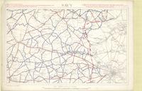
Title
Savy
Date
1916
Subject
World War, 1914-1918, World War, 1914-1918--France
Identifier
macrepo:74110, local: PC0807
Title
Third Army map : [Lens, Arras Cambrai]
Date
1917-03
Subject
World War, 1914-1918, World War, 1914-1918--France
Identifier
macrepo:74180, local: PC0811
Title
Secret, Watten Bridge Head - Merckeghem Switch - St. Omer - Sercus Line : artillery positions
Date
1918-07-15
Subject
World War, 1914-1918, World War, 1914-1918--France
Identifier
macrepo:73690, local: PC0734ww1map
Title
Secret, Watten Bridge Head - Merckeghem Switch - St. Omer - Sercus Line : artillery positions
Date
1918-07-11
Subject
World War, 1914-1918, World War, 1914-1918--France
Identifier
macrepo:73691, local: PC0735ww1map
Title
Skeleton map of Fifth Army Front : [Bapaume Region, March 2nd, 1917]
Date
1917-03-02
Subject
World War, 1914-1918, World War, 1914-1918--France
Identifier
macrepo:73903, local: PC0743
Title
Skeleton map of Fifth Army Front : [Bapaume Region, March 3rd, 1917]
Date
1917-03-03
Subject
World War, 1914-1918, World War, 1914-1918--France
Identifier
macrepo:73904, local: PC0744
Pages
« first
‹ previous
…
74
75
76
77
78
…
next ›
last »