Skip to main content
Menu
Home
Digital Archive
McMaster
McMaster Library
Browse
By collection
By language
By location
By subject
About
About
Contact
Contact Us
Digital Preservation Policy
Strategic Framework
Implementation Plan
Copyright Approach for Library Digitization
Home
eng
(x)
america
(x)
malsch
(x)
wales
(x)
britain
(x)
Search Digital Archive
Search help
Search results
(221 - 227 of 227)
Pages
« first
‹ previous
…
8
9
10
11
12
Title
Irish Sea: Ordnance Survey of Great Britain : 1/4-inch to one mile, England & Wales
Date
1944
Subject
Identifier
macrepo:61974, local: WW2_England_Wales_253K_02A
Title
England and Wales : special strategic map
Date
1943-05
Subject
Transportation, Transportation--England--Wales
Identifier
macrepo:69414, local: ww2_strategic_map_EnglandWales_1mil
Title
Alnwick & Rothbury
Date
1932
Subject
Identifier
macrepo:69518
Title
Hexham: Ordnance Survey of England and Wales : one-inch map
Subject
Topographic maps, Topographic maps--England--Wales
Identifier
macrepo:69519, WW2_England_Wales_63K_006_POP
Title
A modern map of the post roads of England and Wales, with part of Scotland: Drawn from the latest surveys; corrected & improved by the best authorities
Date
1780
Subject
Identifier
macrepo:78031, local: RMC_4289
Title
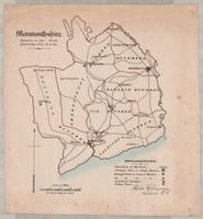
Monmouthshire
Date
1832
Identifier
macrepo:91970, local: RMC_107800
Title
Radnoriensis comitatvs vulgo The Countie of Radnor
Date
1646
Subject
Identifier
macrepo:26704, local: RMC_107248
Pages
« first
‹ previous
…
8
9
10
11
12