Search results
Pages
-
-
Title
-
1944-11, Italy
-
Date
-
1944-11-01
-
Subject
-
-
Identifier
-
macrepo:78624, localcollection: RC0881, Series 1, Box 1, File 13
-
Modat DT date
-
1944-11-01T00:00:00Z
-
![[Vimy Ridge, north]](/islandora/object/macrepo%3A70331/datastream/TN/view)
-
Title
-
[Vimy Ridge, north]
-
Date
-
1916-09-14
-
Subject
-
World War, 1914-1918, World War, 1914-1918--France--Belgium
-
Identifier
-
macrepo:70331
-
![[Bapaume] 57c](/islandora/object/macrepo%3A79540/datastream/TN/view)
-
Title
-
[Bapaume] 57c: France
-
Date
-
1917-02
-
Subject
-
World War, 1914-1918, World War, 1914-1918
-
Identifier
-
macrepo:79540, local: 467WW1MAP
-
![[Tournai, Cysoing Region]](/islandora/object/macrepo%3A70339/datastream/TN/view)
-
Title
-
[Tournai, Cysoing Region]
-
Date
-
1916
-
Subject
-
World War, 1914-1918, World War, 1914-1918--Belgium--France
-
Identifier
-
macrepo:70339
-
-
Title
-
July 1916
-
Date
-
1916-07-03
-
Subject
-
World War, 1914-1918--Trotter, Bernard Freeman, 1890-1917, World War, 1914-1918--Trotter, Bernard Freeman, 1890-1917
-
Identifier
-
macrepo:73801, localcollection: RC0141, Series 1a, Box 1, F.5.
-
Modat DT date
-
1916-07-03T00:00:00Z
-
-
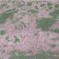
Title
-
Nowy Targ
-
Date
-
1944
-
Subject
-
-
Identifier
-
macrepo:20423, ww2_Poland_100k_U14
-
-
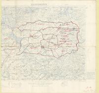
Title
-
Hazebrouck 5A
-
Date
-
1917
-
Subject
-
World War, 1914-1918, World War, 1914-1918--Belgium--France
-
Identifier
-
macrepo:73990, local: PC0788
Pages